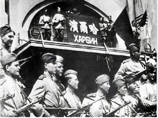
I also wonder why they didn’t create some better resources themselves. Even if they could have appropriated their resources, the resources they themselves created were still no different. Just by searching online myself, I found about the battle on the Soviet-Japanese front. In fact, if we consider it historically, Japan was able to build such urban-like structures. They must have been small fortresses with certain fences around them, because their policy was to gather all the farmers who were farming and have them live together in a closed-off manner for centralized management. Historically speaking, these buildings should have all become ruins because Japan was being steadily defeated by the Soviet Union. In such cases, they left some behind for resistance, carried out large-scale destruction and demolition, and prevented the Soviet army from passing through quickly. The truly important places were definitely the intense battles in the areas with a series of trenches and bunkers, which were the real battles. The other places, as long as they weren’t fortresses, were simply crushed by Soviet tanks.
In which BRs can the frontline be played?
High BR only or all?
I’m assuming all, since the Soviets are getting a BR I Chinese rifle.
…
There was supposed to be a river on the map. I thought it looked very similar to the Heilongjiang River. But the problem is that the Heilongjiang River is not so small or narrow. I think this place seems different. If I asked the people in Harbin, they wouldn’t say anything. Just this layout is completely different from what his home should be like.
It is probably inspired by Harbin but not fully accurate like Berlin or Stalingrad.
I agree with the colours. I think the city is too brightly coloured and resembles Burma too much. Also there is not much building variation
I want to tell you that this is absolutely impossible. Japan attached great importance to Manchuria and intended to turn it into a “second Japan”—that is precisely why Japan invaded this region and China. Moreover, the Kwantung Army was extremely well-equipped; even when compared to other countries’ forces, it was undoubtedly among the most elite within Japan itself. The torii gate can be said to have been brought over by the Japanese military during their colonization here, constructed by residents of the Japanese colonial settlements (Kaitaku-tai) and local shrines. However, you need to understand that this game was developed by people who may have even less knowledge of this history than we do. They might have looked at these photos, thought they resembled those from Burma, and simply copied and pasted them, claiming the location is within Chinese territory while directly using Southeast Asian architectural models. In short, it’s an extreme display of perfunctoriness. If Japanese-style buildings appear, it indicates this was an area where Japanese military personnel or civilians resided—and as such, it should definitely be a small fortress complete with surrounding walls. Historically, Japan’s land enclosure policies against local Chinese residents were extremely harsh, as the black soil here was incredibly valuable.
If the developers are using Harbin as the model, it could be Songhua River. But this river is also much wider that it seems to be in the game. And the city is too small compared with Harbin at that time. What’s more, sounds like there is no famous landmark in the game map. For example, the St. Sophia Cathedral, the St. Nicholas Cathedral, the police station of the Manchukuo puppet regime, the city hall of the puppet regime, the office building of Qiulin Company, Gogol Street, Central Street, etc.
However, the developers tend to create a city with a river crossing it, Russian elements, and city railway train system(this is rare in China at that time), these features make Harbin almost the sole model for developers. But you are correct. Harbin is not so ugly, and so small either. So this game map is fairly confusing
This is simply unbelievable. It seems developers should be Russians or Eastern Europeans. How could they not know which houses to build for a harsh winter? From an architectural standpoint, this is a complete mistake. When Soviet troops were destroying Japanese units, their bunkers and the Quanton Army headquarters remained untouched. A gaming friend of mine, who consulted locals, said that the wall thickness in the preserved Quanton Army headquarters might exceed the length of an elbow. It looks like they didn’t even ask local Chinese opinions—just blindly copied superficial details. I think their approach is extremely unserious. If you can’t use maps of the Pacific region with their straw huts, then what are they going to do? Will they use these wooden houses for Siberian winters? In the worst-case scenario, I’d ask them at least to standardize the color scheme of these buildings or change the shades—they’re too much like Myanmar, and it drives me crazy.
It is not accurate at all, pal. But the city in the new map appears to be with a river crossing it, Russian elements, and city railway train system(this is rare in China at that time), Umm, these features make Harbin almost the sole model for developers.
Is it true that Japanese BR3 will match up against BR4?
I was thinking of buying the new Premium MG squad, but I decided against it.
Current Japanese BR3 doesn’t have the capability to take down other nations’ BR4. Nice balance, huh?
@SnowieW
@MajorMcDonalds
May I ask if you can understand this question?
Similar to:
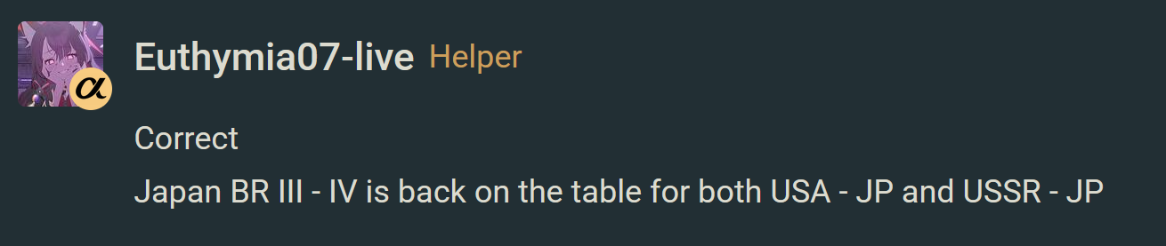
During the Soviet era, the post office in Moscow would not display the plaque of the Tsarist Post Office or the sign of the Tsarist Post Office.
The Russian Federation no longer has the Soviet postal department either.
There will be no post office in the French Republic hanging the post Office of Emperor Napoleon or the Imperial Post Office.
The Federal Republic of Germany would not allow their post offices to bear the names of Nazi, Fascist, the Third Reich, or Hitler either.
The United States will not tolerate the names of its government departments or cooperative institutions having the words “British colonies”, “French colonies”, or “Spanish colonies”
Although there are a large number of incorrect urban and rural buildings, road planning, hydrological environment and topography on the Manchuria-Harbin map, making this problem seem like just a drop in the ocean.
However, this plaque is not an isolated case. A large number of such plaques and signs with such characters and symbols can be found on the map.
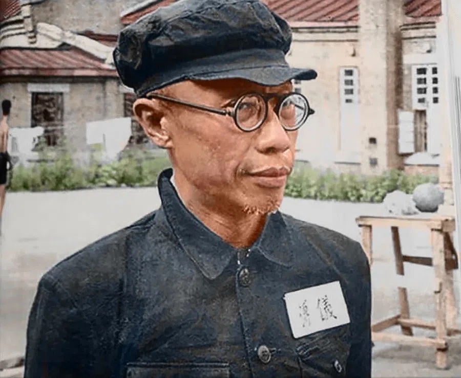
In 1945, it had been 33 years since the fall of the Qing Dynasty!
It has been 113 years since the Qing Dynasty ceased to exis,nowt!
Don’t touch my puppet post office please ![]()
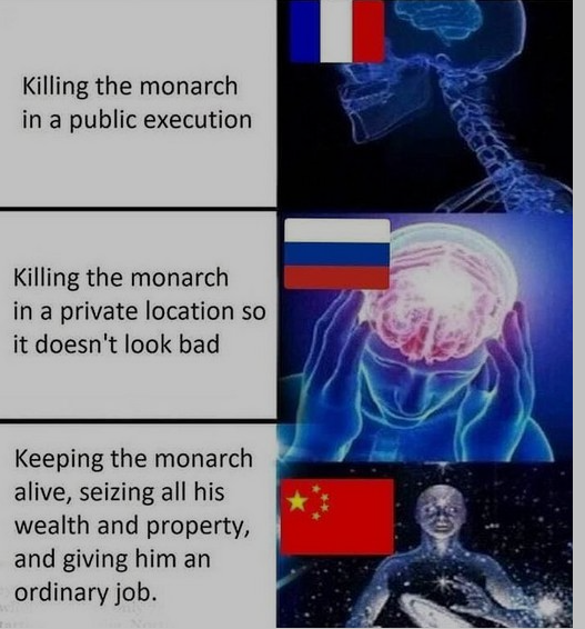
The wholesome ending.
The good ending ![]()
Hi, first of all, thank you for feedback.
Correct me if I’m wrong. The point is that it was no longer imperial, but became the Chunghwa Post, and its correct Chinese spelling is 中華郵政.
It’s great that after starting the new week’s work, you were able to quickly collect and think about feedback and suggestions regarding the new map.
And began to prepare for revision actions.
Therefore, I have decided to provide you with some public map information about the city of Harbin.
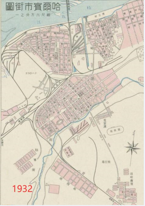
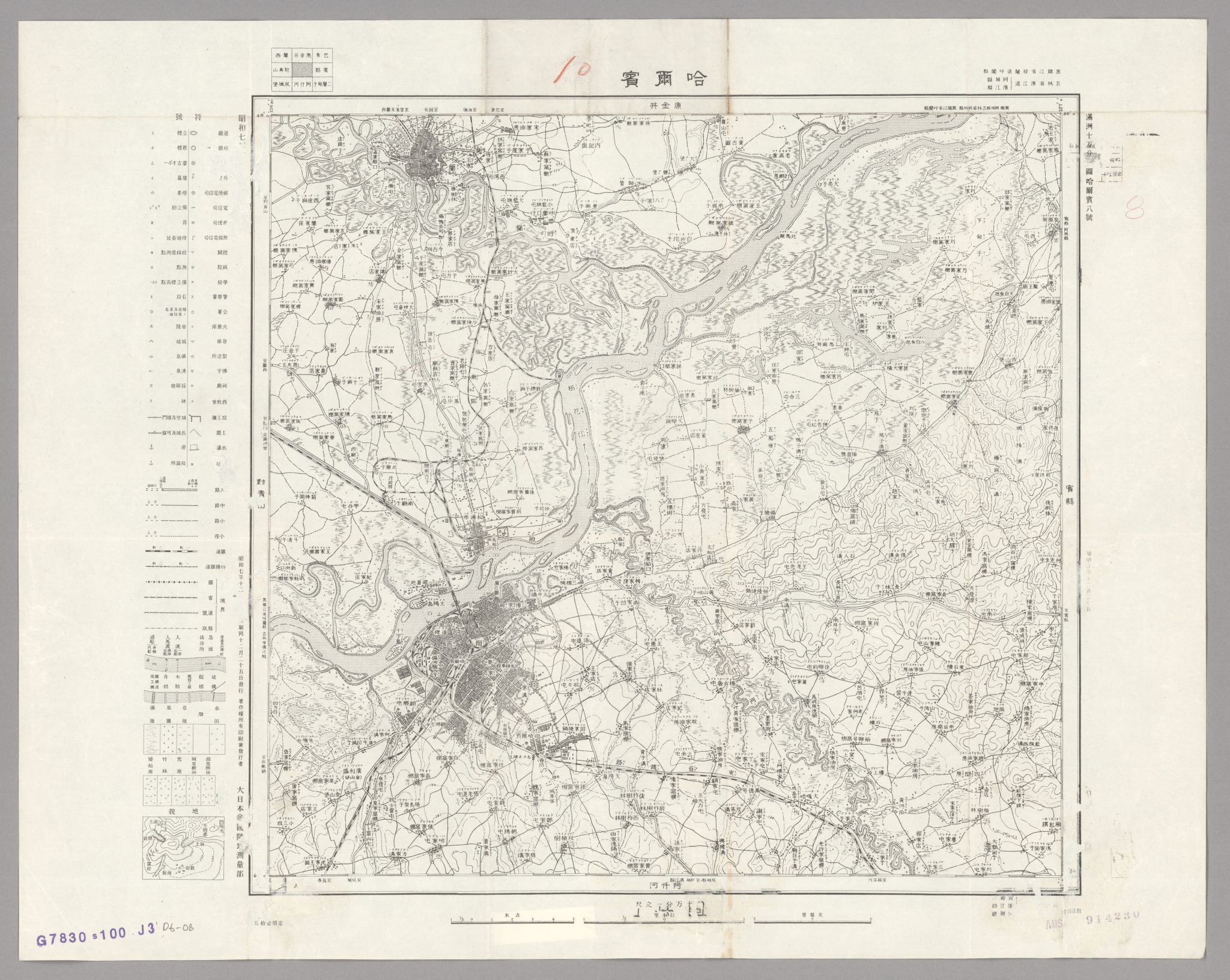
↑The distribution map of houses in Harbin in 1932 and the geomantic map of Harbin City in 1932.
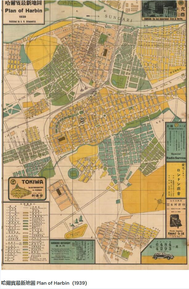
↑The map of Harbin in 1939。

↑The street map of Harbin in 1940。
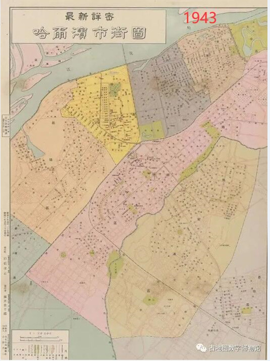
↑The map of Harbin districts in 1943。
As for the landmark buildings in Harbin, they are more likely to have their corresponding materials retrieved.
PS: In the administrative divisions of Harbin urban area, there are Daoli District and Daowai District. It is divided with the Binzhou Railway as the dividing line.
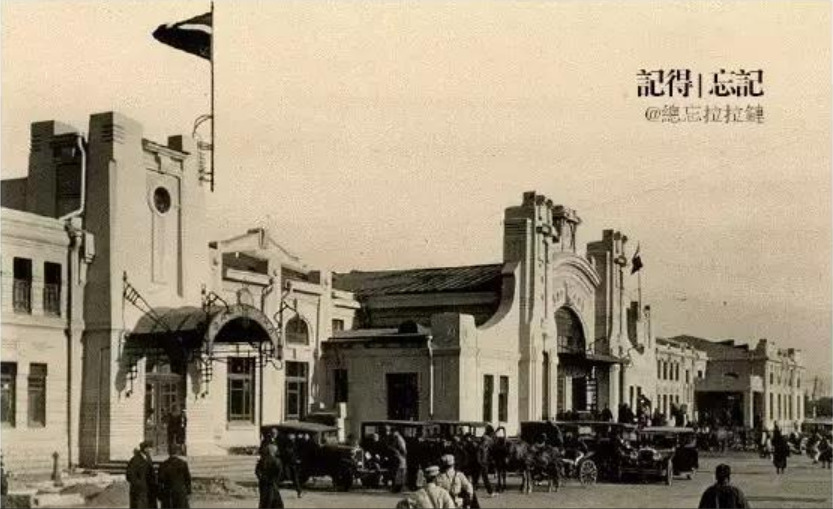
The ancient Harbin Railway Station is quite magnificent.
In 1945, Harbin had over 700,000 settlers.
In 1990, Harbin had a population of 8,834,600 .
In 1898, Moscow had a population of 8,967,000.
I’ll say it again: as with Burma and the Ardennes, the city’s design is more inspired by Harbin, but it won’t be a 1:1 copy of Harbin because we have certain texture constraints we need for pre-gen consoles. Increasing the number of unique buildings would also push us up against the limitations of prev-gen consoles. Plus, purely urban gameplay is very boring, as Berlin demonstrates. So we had to resort to simplifications and conventions.
About post office: The main point is that it was no longer imperial, but became the Chunghwa Post, and its correct Chinese spelling is 中華郵政 ? Is it more correct?